THE MOMENT
Can wildlife management data help me find promising public hunting land without someone telling me where to go?
For Presidents' Day weekend in February 2027, I'm planning a hunting trip with my dogs to the mountains of North Carolina.
I'm relatively new to upland hunting, and one of the skills I want to develop is finding productive habitat on my own. I don't want to depend on someone handing me a location or telling me where they found birds last season. I want to understand what makes a place worth hunting in the first place.
My primary targets are bobwhite quail and ruffed grouse. Rabbits and squirrels are secondary opportunities if the bird hunting is slow.
That gives me an interesting challenge: finding public land with suitable habitat for two very different upland birds, while still offering enough diversity to make a long weekend worthwhile.
Instead of starting with recommendations from other hunters, I decided to start with the data.
Starting With the Wildlife Management Plans
The North Carolina Wildlife Resources Commission (NCWRC) manages public game lands across the state. One of the most useful resources I've discovered is its collection of game land management plans.
These documents go well beyond showing where hunting is allowed.
They describe the habitats found on individual properties, the wildlife species those habitats support, and the management practices intended to maintain or improve conditions over time.
For someone learning to evaluate public land, that's valuable information.
I began comparing game lands in North Carolina's mountain region, paying particular attention to habitat diversity, forest management, and the species identified in each plan.
The goal wasn't necessarily to find the largest property. It was to find one with the right combination of habitat types.
Why More Acres Don't Necessarily Mean Better Hunting
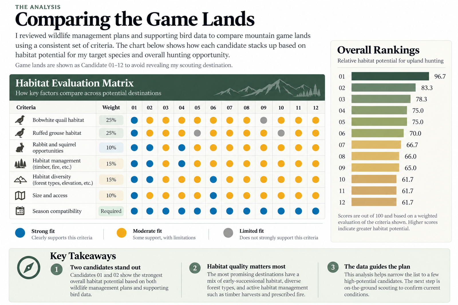
Comparing potential hunting destinations. A weighted habitat evaluation of 12 anonymized North Carolina mountain game lands using wildlife management plans and historical birding records. Scores represent relative habitat potential, not verified wildlife abundance or hunting success. Specific locations are intentionally withheld.
It's easy to assume that more public land means more hunting opportunities.
But a large tract of mature forest might provide limited suitable habitat for bobwhite quail. Likewise, a property with extensive open fields might not offer the dense young forest conditions that ruffed grouse need.
The quality and arrangement of habitat matter more to my research than acreage alone.
For this trip, I'm evaluating four species, with two clear priorities.
Primary targets
- Bobwhite quail: Grasses, forbs, early-successional vegetation, and protective shrub cover.
- Ruffed grouse: Young forests, dense woody regeneration, and transitions between forest age classes.
Secondary targets
- Eastern cottontail rabbit: Brushy edges, thickets, and dense ground-level vegetation.
- Gray and red squirrels: Hardwood forests with mast-producing trees, particularly oaks and hickories.
There's some overlap between these habitats, but not enough to treat them as interchangeable.
A promising quail field isn't necessarily good grouse cover. A mature hardwood stand that offers squirrel opportunities might provide little of the dense understory I'm hoping to find for grouse.
Understanding those differences is helping me evaluate each property more critically.
Reading Between the Lines of the Management Plans
As I worked through the NCWRC documents, I started paying attention to more than just the species listed.
I wanted to understand how the land was being managed.
For quail, I looked for descriptions of early-successional habitat and management practices such as prescribed burning, mowing, and maintaining open vegetation.
For grouse, I focused on regenerating forest, young woody growth, and forest management that could create dense cover.
I also paid attention to whether a plan described existing conditions or future management goals.
That's an important distinction.
A proposed timber harvest doesn't mean young forest is already present. A prescribed burn listed as a management strategy doesn't mean it has happened recently. And a species identified as a management target isn't proof that a healthy population currently occupies the property.
These plans are useful evidence, but they aren't live reports of wildlife abundance.
That realization changed how I approached the research. Rather than asking, "Which game land has the most birds?" I started asking, "Which game land gives me the strongest habitat-based reason to investigate further?"
Making Sure the Seasons Line Up
Before committing to a destination, I also needed to confirm that my target species would be in season.
I'm planning to hunt on Saturday, February 13, and Monday, February 15, 2027, with Sunday reserved for exploring the surrounding area.
According to NC Wildlife's published 2026–2027 season-date information, my target species have the following statewide seasons:
- Bobwhite quail: November 21, 2026 – February 28, 2027.
- Ruffed grouse: October 12, 2026 – February 28, 2027.
- Rabbit: October 12, 2026 – February 28, 2027.
- Gray and red squirrels: October 12, 2026 – February 28, 2027.
All four are scheduled to be in season during the planned weekend.
I'll still confirm the final regulations, game land rules, and any applicable restrictions before heading out.
Season dates are an important filter in the research process. Finding promising habitat doesn't do me much good if I can't legally hunt the species I'm targeting when I arrive.
Choosing a Destination Without Finding a Hotspot
After reviewing the management plans and comparing habitat characteristics, I selected a game land in North Carolina's mountain region.
It offers a combination of habitat types that appear relevant to my primary targets, along with potential opportunities for rabbits and squirrels.
That's enough for me to move forward with more detailed scouting.
But I'm not claiming to have found a hotspot.
I haven't walked the property yet. I haven't verified the condition of every habitat type described in its management plan. And I don't have current population data demonstrating that quail or grouse are abundant there.
What I have is a research-backed reason to invest more time in this particular property.
For now, that's exactly what I was looking for.
Sharing the Method, Not the Location
While researching this trip, I came across Project Upland's article, The Ethics and Issues of Hotspotting in Hunting.
It made me think about how much detail I should share publicly.
Public land belongs to everyone, but productive hunting locations often represent years of scouting, observation, and effort. Publishing a specific location can direct additional pressure toward an area that other hunters have worked hard to understand.
I want Field Notes & Data to document how I'm using information and technology to become a better hunter. I don't need to reveal the exact game land or my scouting locations to accomplish that.
Throughout this series, I'll share the resources I use, the habitat characteristics I look for, and the decisions I make along the way.
I'll keep the specific hunting ground, access points, and saved waypoints private.
The goal is to share a process other hunters can apply to their own research—not give away a destination.
What the Research Has Actually Accomplished
At this stage, I haven't found a single bird.
But I've narrowed a large number of possible destinations into one property worth investigating.
More importantly, I'm starting to develop a repeatable process for evaluating public land.
Instead of relying on acreage, reputation, or secondhand reports, I'm looking at habitat structure, wildlife management objectives, and whether those conditions align with the species I want to hunt.
There are still plenty of unknowns. The habitat might look different on the ground than it does in the management plan. Bird populations may be limited. Some of the most promising areas might be difficult to access.
That's why selecting a destination is only the beginning.
Where AI Helped—and Where I Made the Decisions
One of the tools I used throughout this research was ChatGPT.
North Carolina's game land management plans contain a considerable amount of useful information, but comparing multiple properties means working through lengthy documents that aren't necessarily organized the same way.
I used ChatGPT to help summarize those documents, identify relevant habitat characteristics, and organize information into a consistent comparison framework.
The process focused on several questions:
- Which properties have habitat suitable for bobwhite quail and ruffed grouse?
- What management practices, such as prescribed burning and timber harvesting, are documented?
- How do opportunities for rabbits and squirrels affect the overall suitability of a destination?
- What additional evidence could help distinguish promising habitat from management objectives that haven't yet been realized?
I also incorporated historical birding checklists where available. These provided another perspective on reported species occurrence, although they couldn't establish current wildlife abundance.
Turning Research Into a Comparison
With AI assisting in organizing the information, I developed a weighted evaluation of 12 mountain-region game lands.
Bobwhite quail and ruffed grouse received the greatest emphasis because they're my primary hunting targets. Habitat management, habitat diversity, secondary species, and access considerations contributed to the overall assessment.
The resulting visualization helped me compare properties using a consistent set of criteria rather than relying on acreage or reputation alone.
Where Human Judgment Matters
AI can make research more manageable, but it doesn't eliminate the need to question the evidence.
A management plan might describe habitat improvements that are only proposed. A historical birding checklist might report a species that is no longer common in the area. And a high habitat suitability score doesn't guarantee that I'll find birds when I arrive.
I treated the AI-assisted comparisons as a decision-support tool, not a definitive ranking of wildlife populations.
I decided which species mattered most, how to prioritize the evaluation criteria, what limitations to acknowledge, and which destination deserved further investigation.
The final decision was mine.
The next step is to test those assumptions against more detailed habitat information and, eventually, what I observe on the ground.
That's the value I see in AI-assisted research: not replacing judgment, but helping me organize evidence so I can make better-informed decisions.
Next Field Note: Following the Fire
One of the habitat management practices that caught my attention during this research was prescribed burning.
For bobwhite quail, the relationship between fire and early-successional habitat is especially interesting.
My next step is to use the NC Wildlife Prescribed Fire Dashboard to investigate areas where burns have been completed within the past four years.
I'll compare those records with satellite imagery in onX Hunt to see whether I can identify promising quail habitat before setting foot on the property.
The question for the next Field Note is simple:
Can prescribed fire records help me find better places to start scouting for bobwhite quail?
Sources & Research
The following resources informed my destination research or will support the next stage of scouting.
North Carolina Wildlife Resources Commission
- Game Lands — Official information about North Carolina's public game lands, access, and hunting opportunities.
- Hunting Regulations — Official regulations and hunting-season information.
- 2026–2027 Hunting and Trapping Season Dates — NC Wildlife's season-date reference used to check the quail, grouse, rabbit, and squirrel seasons. The reference was labeled tentative; I'll verify final regulations before the trip.
- Game Land Management Plans — NC Wildlife's individual property management documents, which I used to evaluate habitat types, management objectives, and wildlife species. I'm intentionally not linking the specific plan for my selected destination.
Habitat Research Tools
- NC Wildlife Prescribed Fire Dashboard — Interactive mapping resource I'll use to investigate completed prescribed burns and potential quail habitat.
- onX Hunt — Digital mapping tool I'll use for satellite imagery, terrain, public-land boundaries, and preliminary habitat scouting.
Hunting Ethics
- The Ethics and Issues of Hotspotting in Hunting — Project Upland — An article that influenced my decision to share research methods while keeping specific hunting locations private.
Field Notes & Data — Curious inquiries. Real data. AI-assisted answers.
THE OBSERVATION
What stood out?
I evaluated habitat suitability using NCWRC management plans and checked published hunting season information. I selected the destination based on my hunting priorities and chose not to disclose the specific game land or scouting locations. Actual habitat conditions and wildlife abundance have not yet been verified in the field.
FIELD DETAILS
Context without clutter.
North Carolina Mountains · October 22, 2026
Wildlife management plans describe habitat conditions and management objectives, but do not necessarily reflect current conditions or animal abundance. Suitable habitat does not guarantee huntable populations. On-the-ground scouting is needed to validate the research.